


Garmin GPSMAP 79sc, Marine GPS Handheld Preloaded With BlueChart g3 Coastal Charts, Rugged Design and Floats in Water
Details
- BrandGarmin
- Model NameGPSMAP 79sc
- Vehicle Service TypeBoat
- Screen Size6 Inches
- Special FeatureDesigned to
- Connectivity TechnologyUSB

Description
🌟 Elevate Your Adventure with Garmin GPSMAP 79sc!
- MEMORY MASTER - Store up to 10,000 waypoints and 250 routes for all your adventures.
- RUGGED READY - Designed to float and withstand the elements with IPX6 water resistance.
- LONG LASTING POWER - Enjoy up to 20 hours of battery life in GPS mode for extended journeys.
- PRECISION TRACKING - Multi-satellite support ensures reliable tracking anywhere on the globe.
- NAVIGATE WITH CONFIDENCE - Equipped with preloaded BlueChart g3 coastal charts for seamless navigation.
The Garmin GPSMAP 79sc is a rugged, floating handheld GPS designed for marine use, featuring preloaded BlueChart g3 coastal charts, multi-satellite support, and a high-resolution display. With a water-resistant design and up to 20 hours of battery life, it's perfect for outdoor enthusiasts seeking reliable navigation.


Specifications
| Display Type | Transflective, 65K Color TFT |
| Human-Interface Input | Buttons |
| Compatible Devices | Smartphone, Tablet |
| Control Method | Touch |
| Are Batteries Included | No |
| Supported Satellite Navigation System | GPS |
| Sport Type | Fishing |
| Battery Average Life | 19 Hours |
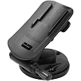
| Mount Type | Wrist Mount, found in image |
| Resolution | 240 x 400 |
| Compatible with Vehicle Type | Boat |
| Screen Size | 3 Inches |
| Additional Features | Designed to Float; Increased Memory; Built-in Compass; BlueChart Coverage |
| Connectivity Technology | USB |
| Map Types | North America |
| Item Weight | 0.62 Pounds |
| Item Dimensions L x W x H | 2.6"L x 1.2"W x 6"H |
Have a Question? See What Others Asked
Reviews
H**M
Quick ship - “Fresh” unit
Unit had the latest software loads including system software and BlueChart loads. Very quick delivery. Nice! This was purchased as a backup unit for one bought a year ago. Still learning how to use the routing and recording features. It has not been completely intuitive but the manual full download helps. Accuracy & startup time are excellent. Predicted battery life of 19 hours seems accurate but wish it was 24 hours…. A very solid unit.
B**N
NMEA output Capable
Garmin has never been good at describing features or how to use them on their GPS systems. It is certainly the case for this very capable handheld GPS device. One must learn by scrolling through the menus and getting your device to do what you want it to.I got this Garmin GPSMAP 79sc to replace my 76Cx which, after years of using, had a simple battery compartment issue I was unable to fix. I had set up and used my old Garmin to, among other things, communicate NMEA streams of data to my autopilot on my sailboat. I shopped online, even at the official Garmin site, and looked for this feature among GPS handhelds with no luck. I even went into a retail store to talk with knowledgeable salespeople as to what product would do this. No luck. But while having the 79sc in my hand, I noticed it had the Garmin round plug port for power and I/O which wasn’t even mentioned or shown in online descriptions. The Quick Start booklet which came in the box said nothing about the port, and the owner’s manual, which I had to download, had little. I took a chance and bought it. Turns out I could get this working like my old device by exploring the menus. Not much help from any written direction provided by Garmin. It must be a legacy feature not used by many today.The 79sc has many features, some useful to me and some not, but it is very capable. It determines position faster than my old, almost instantaneously. The compass feature is handy and works by some technology alien to me. Probably magic. And the unit I got, being preloaded with coastal charts, is nice. Display is nice. The scrolling buttons are a bit touchy. I’ll wait to test out its waterproof and floating capabilities until I accidentally drop it overboard.So, if you want a very capable handheld GPS, try the Garmin GPSMAP 79sc. Just be patient, explore the device, and get to know each other together.
B**L
Good quality. Poor instructions, confusing, and very small screen.
This is a well made durable unit. The instructions are very confusing and it takes a lot of trial and error to figure out the process. Read the instructions all the way through before attempting to use it and it may seem a little clearer, go one step at a time.
J**S
Marine set-up not for the technically challenged
I had to ask the gps sales person at Hamilton Marine to set up the charts for marine operation. It is not easy. However, since then, I have been able to use and enjoy the features of this gps. I use it planning and tracking multiple weekly ocean kayak trips of 6-15 nautical miles and 2-5 hours. The map does not label smaller islands which is a problem so I always have a paper chart with me. What is excellent is that I can read the screen, mounted on the deck, in all light conditions. Lithium batteries provide me about 15 hours of tracking with this gps. The GPS is exposed to weather and salt as I have it on a Garmin portable mount on the deck of my kayak so I rinse it under the faucet after each trip. After 2 years of use - May through November - it still looks new and has never leaked. I am very happy with this gps.
C**K
Waste of time and money
Very user unfriendly. Went through 3 sets of batteries trying to figure out all desired functions. Inconsistent compass calibration. Display washes out in the sun. No reverse route feature. Returned for refund. Definitely not worth the price.
R**H
Great back up GPS for boating
I bought this as a backup to the main navigation unit on my boat. It's packed with a lot of features, but marking waypoints and navigating to them is just a couple of clicks. I turned off my primary plotter yesterday while fishing offshore and used this to get back to port. The compass navigation mode is the better of the two IMO.The charts are detailed enough to use this unit as a main GPS unit if you also want the ability to use this in other environments such as camping. However, you'll probably find the screen too small when there's bigger units available.
C**.
Prefer Navionics maps on phone better.
Multiple reasons I don’t like this unit.Doesn’t hold micro as card well, falls out.Can’t load and use inland charts and use preloaded coastal charts together, have to toggle between the two. Not a huge problem unless entering a river from bay, sound…Don’t like the chart, prefer Navionics charts better.I knew it had a small non touch screen before purchasing, but really displeased with not having.
Common Questions
Trustpilot
2 weeks ago
5 days ago
